WROXETER ROMAN CITY
Aerial photography and photogrammetry to create 3D models of an iconic archaeological site, including historic farm buildings and excavations in progress. Part of a research project to inform future management and conservation.

Background
Wroxeter was one of the largest cities in Roman Britain. As big as Pompeii, it was important military and administrative centre.
Most of the former city is in the care of English Heritage, and is a popular visitor attraction. Although excavations have taken place from the 1850s, parts of the site had never been explored.
Archaeological excavations in 2024 investigated an area next to the site of the Forum, at the main crossroads which marked the city centre. This was the first research excavation at Wroxeter in more than 30 years.

Scope
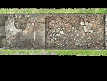
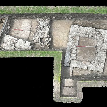
Our role was to provide aerial photography and photogrammetry to create accurate 3D models of the archaeological excavations. Five trenches were excavated in the field next to the Forum.
Part of this also involved the survey and modelling the 19th century Wroxeter Farm, a farm complex built over some important Roman remains. Two trenches were excavated inside the farm buildings.
We also undertook surveys of the preserved baths complex and the replica Roman villa.

Outcomes
The excavation revealed the remains of a substantial public building, along with a possible shrine or temple. The project also discovered an elite town house, with part of the mosaic floor surviving intact.
This was the first mosaic to be revealed at Wroxeter for over 100 years.
We produced accurate georeferenced 3D models of five archaeological trenches, at different stages of the excavation. From these we provided accurate 2D sections, plans and elevations.

3D models
You can explore all of our 3D models on Sketchfab.
Wroxeter Roman Baths: https://skfb.ly/p7SCU
Wroxeter Roman Villa: https://skfb.ly/oZAAs
Wroxeter Farm exterior: https://skfb.ly/p7EAP
Wroxeter Farm barn interior: https://skfb.ly/p7EAR
All models (including trenches): https://skfb.ly/p7pDn

Site history
Wroxeter was founded in the late 40s CE as a legionary fortress, and the city was established by the end of the first century CE. The city was laid out on a classic Roman grid plan, centred on the Forum - near the modern crossroads - and contained 48 city blocks.
At its peak Wroxeter had a population of around 15,000.
Wroxeter continued to be an important centre after the Roman army withdrew from Britain. However it declined from the 6th century and was eventually abandoned. Roman stonework can be found in nearby buildings, including Wroxeter church and the farm.

Further details
The project was led by Dr Roger White (University of Birmingham), Dr Peter Guest (Vianova Archaeology and Heritage Services) and Mike Luke (Albion Archaeology). The work was undertaken on behalf of the English Heritage Trust, with students from the University of Cardiff and elsewhere.
Wroxeter Roman City is a Scheduled Monument in the care of English Heritage.
Images


Project partners


Similar projects
Butrint World Heritage Site
Butrint World Heritage Site
Butrint World Heritage Site
Rowley's House Shrewsbury
Butrint World Heritage Site
Butrint World Heritage Site
Old Oswestry Hillfort
Butrint World Heritage Site
Old Oswestry Hillfort
Heritage Innovation Limited
34-35 Butcher Row • Shrewsbury • SY1 1UW • United Kingdom
Company 14145049
Copyright © 2025 Heritage Innovation