shropshire mining LANDSCAPES
Aerial photography, photogrammetry and landscape survey to inform understanding of a range of complex mining landscapes in south Shropshire. This is a long term research and training project with a range of local partners.

Background
Shropshire is the most geologically diverse counties in England, and mining has taken place here since prehistory. The Romans mined coal, as well as a range of metals including lead, copper and iron.
Mining in Shropshire began to expand during the medieval period, and developed rapidly in the 16th and 17th centuries. Industrialisation increased the scale and pace of mining, with settlements connected through complex networks of tramways and railways.
Metal mining declined in the later 19th century, but dhustone (dolerite) continued to be quarried into the 1960s.

Scope
The numerous upland mining sites in Shropshire are well studied, and many are protected as Scheduled Monuments. Mining landscapes are popular recreational spaces: many people visit the Stiperstones, Long Mynd and Clee hills without always being aware of the rich industrial history beneath their feet.
Heritage Innovation's Shropshire Mining Landscapes project is a long-term programme to capture these spaces in 3D, to create a record and to provide training for future generations.

Outcomes
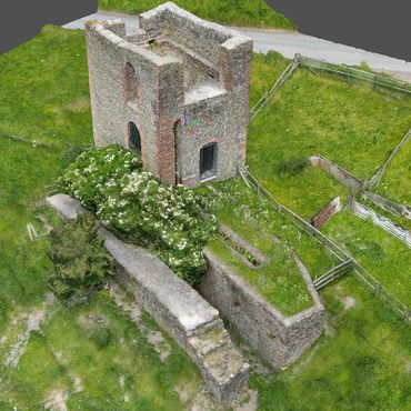
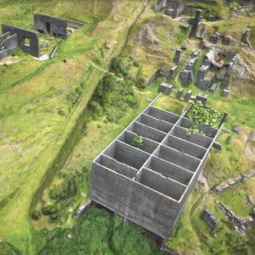
The project is ongoing. So far we have created 3D models of the following sites:
Titterstone Quarry: https://skfb.ly/oXFRU
Ladywell Engine House: https://skfb.ly/p8Sot
Brown Clee Crushing Plant: https://skfb.ly/oOstS
Work continues, mainly during the winter months when the vegetation conditions make it easier to see the subtle changes in the landscape. Please get in touch if you would like to know more, or to get involved.

Find out more
If you would like to know more about mining in Shropshire then check out the Shropshire Mines Trust. They look after the mine buildings at Tankerville and Snailbeach, and provide guided tours.
The Shropshire Mining and Caving Club website also contains a wealth of information about the history of mining in the county.
Images


Similar projects
Old Oswestry Hillfort
Butrint World Heritage Site
Butrint World Heritage Site
Butrint World Heritage Site
Butrint World Heritage Site
Butrint World Heritage Site
Wroxeter Roman City
Butrint World Heritage Site
Wroxeter Roman City
Heritage Innovation Limited
34-35 Butcher Row • Shrewsbury • SY1 1UW • United Kingdom
Company 14145049
Copyright © 2025 Heritage Innovation