Geology and landscape
The Breidden Hills are on the Shropshire-Powys border, and rise above the wide valley of the River Severn. They form three long ridges running north-east to south-west. The main summit (Breidden Hill) is made of very hard, dark volcanic rock, so it stands out sharply from the lower farmland around it.
On the north-west side, cliffs and steep slopes drop down towards the Severn, giving natural protection. The gentler south-east slopes are easier to climb, so people built stronger defences on that side. Nearby, the Long Mountain is another broad ridge on the same border.
A few miles away, Llanymynech Hill is known for its huge hillfort and long history of mining and quarrying. People have been living and working in these border hills for thousands of years.
Early prehistory
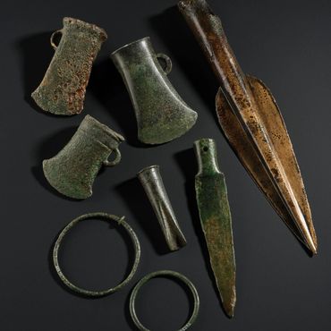
The Breidden first became a significant place for people around 2800 years ago - during a period archaeologists call the Bronze Age.
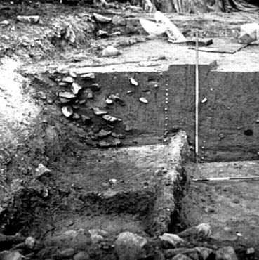
A small village (settlement) was built near the top of the hill. People built a strong bank around it, using a wooden framework filled with earth and stone. This was a large and busy settlement - archaeologists have found evidence for metalworking and weaving, food storage and home life.
Sediment in a large pond nearby (Buckbean Pond) showed that there was a big environmental change at this time, with fewer trees and more grassland. This fits with woodland being cleared and the hilltop being used more intensively.
Later prehistory
The Bronze Age settlement was rebuilt and enlarged during the Iron Age — around 2500 years ago.
At this time the climate was changing. People tried to make the most of the resources they had, and grouped together for safety and security. The defences at the Breidden were rebuilt on a larger scale, probably around 2300 years ago. This suggests the hilltop may have been a stronghold, a meeting place, or both.
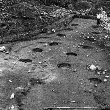
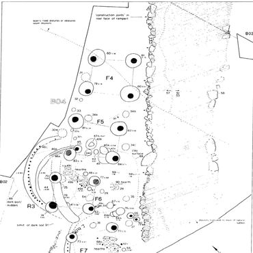
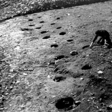
Inside the hillfort, excavations have found the remains of buildings. These included round-houses and small raised structures for storing grain.
People also planned for water. A large man-made water store (a deep, lined hollow) was made near Buckbean Pond, and wooden objects were preserved in its wet ground. This shows that a well-organised community lived and worked on the hill.
Living on the Breidden
Families lived in roundhouses with wooden posts, woven walls sealed with mud, and a thatched roof. A fire in the middle of the house gave warmth and light.
People grew crops such as barley and wheat, and kept cattle, sheep and pigs. Much of the day was spent cooking, fetching water, grinding grain, and caring for animals. Clothes were made from wool and flax, and tools were repaired again and again.
Hillforts could also be social places. People might meet to trade, share news, arrange marriages, or agree rules. The high location in the landscape helped them watch the surrounding territory, and it also gave space for a community to live, work and feel connected.
Romans
When the Romans took control of much of Britain, about 2000 years ago, hillforts quickly lost their role as social centres.
The Romans established new settlements on lower ground, focussed on farming, industry and trade.
The Breidden may have been abandoned for a century or more after the Roman invasion; however by about 1800 years ago the settlement was thriving once again. Archaeologists have found pottery and coins which suggest that people were living here until around 1200 years ago.
This later use may have been more about farming than defence. Across the border region, people gradually relied less on hilltop forts and more on farmsteads, fields and new road routes. The hill remained important in the landscape, even as daily life shifted down into the valleys.
Admiral Rodney
Admiral Rodney (1718–1792) was a senior Royal Navy officer in the 1700s. He went to sea as a teenager and built his career through long years of service. He became well known during wars against France and Spain.
In 1780 he defeated a Spanish fleet at Cape St Vincent and helped bring supplies to Gibraltar during a major siege. His most famous victory came in 1782 at the Battle of the Saintes in the Caribbean, where his fleet beat the French and protected British islands in the West Indies.
After this he was made a peer, becoming Baron Rodney. He was praised as a bold commander, but he was also criticised at times for decisions that seemed to put money or politics first.
Rodney's Pillar
Rodney’s Pillar is the tall stone column on the top of Breidden Hill.
It was built in 1781–82 by local supporters, who described themselves as the 'gentlemen of Montgomeryshire', to celebrate Admiral Rodney’s naval victories while he was still alive.
The pillar is made from local stone, and quickly became a landmark over the Upper Severn valley. In 1847 lightning damaged the top, and the original gilded ball was replaced by the drum and finial seen today.
The pillar is protected as a Scheduled Monument. In recent years it has needed work to keep it safe; its exposed position means that weather has created some structural issues. This is why it is fenced off.
Criggion Quarry
At the south-western end of Breidden Hill lies Criggion Quarry, cut into the hard volcanic rock.
Quarrying has changed the shape of the hill and is easy to spot from the valley. The quarry was first recorded in 1866, but there may have been earlier workings before then. For many years it was worked as one very high rock face, once described as about 600 feet tall.
In the past, men worked on ropes on narrow ledges, drilling into the rock. Today the quarry uses modern machinery to produce crushed stone used mainly for road building.
Quarrying brings jobs and materials, but can also create noise and dust - and potentially damage archaeology and wildlife habitats. Modern quarrying requires careful planning, clear boundaries and protection zones, and well-designed restoration.
Archaeology
People have been curious about the Breidden for a long time. Finds were reported in the late 1800s and early 1900s, including flint arrowheads. In the 1930s, archaeologist B. H. St J. O’Neil carried out the first major excavations at the main entrance, helping to show that the hilltop had a long history.
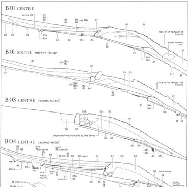
A much bigger programme began in 1969, when quarrying threatened parts of the hillfort. This was “rescue archaeology”: digging quickly to record what might be lost. Over several seasons (mainly 1970–76), teams opened trenches across the ramparts and inside the fort, and later worked around Buckbean Pond when the quarry area expanded. They used careful recording, dating tests, and environmental study of the pond mud, which also preserved rare wooden objects.
Survey and monitoring continue to guide protection and management today.
Forestry
Much of the Breidden woodland is managed for several aims at once: timber, wildlife, heritage care and public access.
Natural Resources Wales manages a Forest Resource Plan area of about 253 hectares, which includes Breidden Hill and nearby woodland blocks. Many planted areas are conifers, with patches of broadleaf trixed in.
Forestry work involves thinning and felling trees in planned stages, then replanting or allowing natural regrowth. Paths and bridleways are also important, because many visitors walk up to Rodney’s Pillar.
Across the wider Criggion estate area, land use is mixed: woodland, farmland, recreation routes and the quarry. Good management tries to balance all these uses and reduce harm to historic earthworks and sensitive habitats.
Conservation
Conservation here means looking after both heritage and nature.
The hillfort banks and entrances can be worn away by heavy footfall, bikes, erosion and water run-off. Bracken, scrub and tree roots can also disturb buried remains, while old forestry planting can hide earthworks.
At the same time, Breidden Hill is a protected wildlife site because its rocky slopes and thin soils support rare plants and special lichens. Some lichens are sensitive to air pollution and to shading by trees. Long-term solutions include clear paths and drainage, careful scrub control, well-planned forestry near earthworks, and targeted grazing to keep grassland open.
Regular surveys, good signage, and working with local communities help protect the Breidden for the next generation.